Before There Was Laguna Seca,
There Was Pebble Beach
 News
Flash! The old Pebble Beach road race course is about to be
demolished. The
management of Pebble Beach has won voter approval to construct a new
golf course over the site of the old Pebble Beach road racing course. Some of the
original roads will be torn up, permanently erasing the course
of the old races. Read more here.
News
Flash! The old Pebble Beach road race course is about to be
demolished. The
management of Pebble Beach has won voter approval to construct a new
golf course over the site of the old Pebble Beach road racing course. Some of the
original roads will be torn up, permanently erasing the course
of the old races. Read more here.

Yes, Virginia, there really was a Pebble Beach Road Race. And now it
comes to GPL.
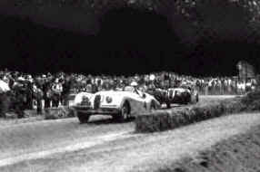
 Phil Hill won the very first Pebble Beach Road Race in 1950 in a
Jaguar (shown below) with a bad clutch. Since then, many of the greats of American and European
road racing passed through this leafy town, racing down frighteningly narrow
country roads in the days before Laguna Seca was built.
Phil Hill won the very first Pebble Beach Road Race in 1950 in a
Jaguar (shown below) with a bad clutch. Since then, many of the greats of American and European
road racing passed through this leafy town, racing down frighteningly narrow
country roads in the days before Laguna Seca was built.
 The
racing course is 2.1 miles of narrow road through the trees of this coastal
town. It's difficult to pass, most of the corners are blind, and sturdy tree
trunks take the place of safety barriers. In short, it's a Real Man's track. I
hope you like it.
The
racing course is 2.1 miles of narrow road through the trees of this coastal
town. It's difficult to pass, most of the corners are blind, and sturdy tree
trunks take the place of safety barriers. In short, it's a Real Man's track. I
hope you like it.
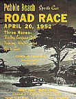
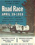
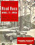
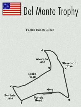
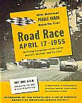
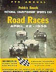
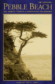
About the Track
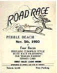 The annual "Del Monte Trophy" was run on the streets of Pebble Beach beginning in 1950 and ending in
1956 after driver Ernie McAfee died racing his Ferrari into a tree (very easy to do, as
you will see). Over the winter the locals made arrangements for some local government land to be
set aside for a purpose-built race track. The next year Laguna Seca ("dry
lagoon" in Spanish) was opened. Road racing forever shifted from Pebble Beach to Laguna
Seca,
which is barely five miles away and a far better facility, as any modern racer will tell you.
The annual "Del Monte Trophy" was run on the streets of Pebble Beach beginning in 1950 and ending in
1956 after driver Ernie McAfee died racing his Ferrari into a tree (very easy to do, as
you will see). Over the winter the locals made arrangements for some local government land to be
set aside for a purpose-built race track. The next year Laguna Seca ("dry
lagoon" in Spanish) was opened. Road racing forever shifted from Pebble Beach to Laguna
Seca,
which is barely five miles away and a far better facility, as any modern racer will tell you.
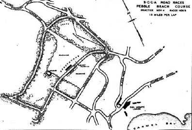
 In its first year (1950), the Pebble Beach Road Race was run on a shorter course than the one you see here. It was 1.8 miles long and cut off the sharp left-hand turn and the hairpin of the newer course, T3 and T4. You can see in my
GPL track where the dirt trail leaves the track at T3 and rejoins it at T5, the beginning of the long downhill straight. This portion of the track was
actually packed dirt; it was never paved and is still not paved to this day.
In its first year (1950), the Pebble Beach Road Race was run on a shorter course than the one you see here. It was 1.8 miles long and cut off the sharp left-hand turn and the hairpin of the newer course, T3 and T4. You can see in my
GPL track where the dirt trail leaves the track at T3 and rejoins it at T5, the beginning of the long downhill straight. This portion of the track was
actually packed dirt; it was never paved and is still not paved to this day.
This 1.8-mile short course was used only once. For the six subsequent races (1951
- 56) the track was extended to 2.1 miles by adding the turns mentioned above. The road immediately following the hairpin (T4) was not paved during
that time. In fact, much of that road is still not paved today. However, I chose to cover this portion with
asphalt to make it easier to race on. Forgive the minor technical
inaccuracy.
 Where the
Hell is Pebble Beach?
Where the
Hell is Pebble Beach?
Next door to paradise, naturally. It's on the central California coast,
tucked in between Monterey, Pacific Grove, and Carmel. To the north are San Jose
and Silicon Valley, about one hour's drive away. San Francisco is another hour north beyond that. Los Angeles is about six hours to the south, but who
cares?
Monterey (home of Cannery Row
in the book by John
Steinbeck) is the largest city in the area. Carmel (or Carmel-by-the-Sea, if you must) lies on the southern border of Pebble Beach,
and is also on the coast. And yes, Clint Eastwood used to be the mayor of Carmel about 15 years
ago, but not any more. Pacific Grove is the least well known of the four towns in this area, but in
many ways the most charming.
It forms the northern border of Pebble Beach.
Pebble Beach is known for its golf, the annual Pebble Beach Concours d'Elegance, the golf, the
Monterey Historic automobile
races, the golf, the picturesque 17-Mile
Drive, the golf, the Bing Crosby
"clambake," the golf, and the nearby Laguna Seca race track. It's also a hideously expensive place to live, with a
median home price of
over $1 million. And there's not
even any sidewalks (pavement).
 Many
first-time visitors expect Pebble Beach to be a deluxe resort town, something
like Beverly Hills or Monte Carlo. In reality, the opposite is true. Pebble
Beach is very rural in character, with nothing but trees in most of the town.
Local maps call this area Del Monte Forest. There are no sidewalks
(pavement), no streetlights, and no business district. There is no downtown.
Residents shop in nearby Pacific Grove, Carmel, or Monterey. Except for the famous golf
courses and their souvenir shops, the town is mostly sand and trees, with houses
hidden behind the latter.
Many
first-time visitors expect Pebble Beach to be a deluxe resort town, something
like Beverly Hills or Monte Carlo. In reality, the opposite is true. Pebble
Beach is very rural in character, with nothing but trees in most of the town.
Local maps call this area Del Monte Forest. There are no sidewalks
(pavement), no streetlights, and no business district. There is no downtown.
Residents shop in nearby Pacific Grove, Carmel, or Monterey. Except for the famous golf
courses and their souvenir shops, the town is mostly sand and trees, with houses
hidden behind the latter.
Technically, Pebble Beach isn't a city at all -- it's a corporation. California
state government considers Pebble Beach to be unincorporated forest land, not a
normal town. The land is privately owned and just happens to be run like a city. The official
"town" Web site is at www.pebblebeach.com. It even costs money to enter:
They charge $8.25 per car to take the scenic 17-Mile
Drive, which is the only way in or out of Pebble Beach. You can check the
local weather here.
 Modern
Day Roads
Modern
Day Roads
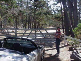
Click here to see how the track looks
today.
With just an old hand-drawn map to go by, it was a little tough at first to figure out where the race really was. Some of the old roads are gone or rerouted and a few modern roads have been built. Some of the street names have also shifted since the 1950s, which made the old map seem
incorrect and misleading.
Today you can drive most, but not all, of the old track. From the start/finish line up until the hairpin at T4 it's no problem. However, the road from T4
until halfway to T5 no longer exists; someone built a house on top of it. The road from T4 leading to to T5 is now someone's driveway!
 Past the house you can pick up the road again near T5. This is a modern paved road, added sometime after 1960 and called Bristol Curve. (Do you think someone on the Pebble Beach City Council had a sense of history?) After only a few yards
this road degenerates into a dirt path again, just as it was during the races. You are free to walk this path but you can't take a car on it. Some trees have grown across this part of the course. The trees are obviously younger than 40 years. From T5 onwards, you can again drive the old course exactly as it was. If you want to check out the old 1.8-mile course from 1950, you again have to get out of your car and walk the dirt-lined shortcut between T3 and T5.
Past the house you can pick up the road again near T5. This is a modern paved road, added sometime after 1960 and called Bristol Curve. (Do you think someone on the Pebble Beach City Council had a sense of history?) After only a few yards
this road degenerates into a dirt path again, just as it was during the races. You are free to walk this path but you can't take a car on it. Some trees have grown across this part of the course. The trees are obviously younger than 40 years. From T5 onwards, you can again drive the old course exactly as it was. If you want to check out the old 1.8-mile course from 1950, you again have to get out of your car and walk the dirt-lined shortcut between T3 and T5.
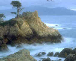
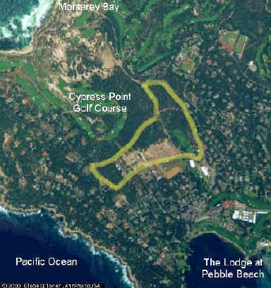
Local Scenery
 As you can see from the aerial photos, the race course lies just a few hundred yards from the Pacific Ocean and the rocky California coastline. Your closest approach to the water is between T1 and T2
(Sombria Lane), which parallels the beach. If I was better at creating 3DO scenery, you might be able to see the water from the track ;-)
As you round T2 and follow the wiggly "straight" to T3, the Cypress Point golf course is to your left. If you could break through the trees you could park your car on the 12th
fairway.
As you can see from the aerial photos, the race course lies just a few hundred yards from the Pacific Ocean and the rocky California coastline. Your closest approach to the water is between T1 and T2
(Sombria Lane), which parallels the beach. If I was better at creating 3DO scenery, you might be able to see the water from the track ;-)
As you round T2 and follow the wiggly "straight" to T3, the Cypress Point golf course is to your left. If you could break through the trees you could park your car on the 12th
fairway.
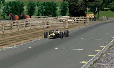
The track circles around a local riding school and
stables. These are pretty
obvious from the start/finish line. The broad flat areas in the infield (right
of the track) and outfield (left side) are used for horse shows, jumping, and riding. During the races
I assume these held temporary pits and grandstands, but there's no evidence of
this now.
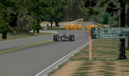
The track passes the Pebble Beach Driving Range just before the S/F line. If
you've ever watched the AT&T Pebble Beach Pro-Am on television, you've
probably seen both professional golfers and celebrities here.
As you round the gentle right-hander at T5, the road behind you leads uphill to
R L Stevenson high school. The school was named after
author Robert Louis Stevenson, who spent some time in the
Pebble Beach area. In fact, his book Treasure Island was inspired by the local scenery. That's why
golf courses around here have names like Spyglass Hill, Spanish Bay, and Stillwater Cove.
 Notes for
Anoraks
Notes for
Anoraks
The actual elevation of this part of Pebble Beach ranges between 130 feet and 210 feet above sea level. I
lowered all these values by 100 feet to make the math easier and so I wouldn't fall off a cliff while building the track. If you notice your
carburetion is incorrect because of the lower altitude, you can blame me ;-)
 Because the real-world track is so close to the beach, the soil is very sandy here. Grass doesn't grow very well and most trees tend to have
very long, tall trunks so they can catch moisture from the coastal fog and mists. I tried to model the trees
and flora as well as I could.
Because the real-world track is so close to the beach, the soil is very sandy here. Grass doesn't grow very well and most trees tend to have
very long, tall trunks so they can catch moisture from the coastal fog and mists. I tried to model the trees
and flora as well as I could.
As mentioned before, my entire GPL track is paved, even though about 15% of the
real track was really just packed dirt and gravel in the 1950s. Dirt is too hard
(er, difficult) to drive on in GPL, so I paved all the racing surfaces with
asphalt and played with the colors and textures instead.
Since I have few photographs from the actual races I had to guess on an awful lot of things. For example,
where were the grandstands? Was there curbing on the corners? The modern Pebble Beach
roads have some raised curbs around them, but I judged that these would not have been present in 1956
(or 1967) so I left them out. You are now free to take T1 wide without breaking an axle.
There were definitely no Armco barriers employed during the races, so hay bales will have to do. I'm not even sure they used hay bales back then...
 Some of the GPL textures are actual photographs of the track that I took with my digital camera. The asphalt edging, for example, is a digitized photo of the real thing.
The road signs are also from photographs; so are the fences around the paddock
(that's horse paddock). The trees, however, are not accurate and are borrowed (with permission) from
other GPL tracks. If anyone out there can create good cypress trees, please
let me know.
Some of the GPL textures are actual photographs of the track that I took with my digital camera. The asphalt edging, for example, is a digitized photo of the real thing.
The road signs are also from photographs; so are the fences around the paddock
(that's horse paddock). The trees, however, are not accurate and are borrowed (with permission) from
other GPL tracks. If anyone out there can create good cypress trees, please
let me know.
Yes, the track really is that narrow. I measured the actual road surface several times but it still feels awfully narrow when I race on it in
GPL.
Notice any houses or buildings around the racetrack? You won't. Pebble Beach is home to some
5000 residents but most of the houses are hidden behind trees or down little side roads. The town is
very rural in character and looks more or less deserted to the casual observer. The most obvious inhabitants are the visiting golfers. You can spot
'em by their white shoes.
About the GPL Version
 I'm
embarrassed to say this track took me a ridiculous amount of time to complete.
Not because it's so complex (it's not) or because I made it so fantastic (I
didn't), but just because I'm pretty stupid at times. I started in
June 2001 and finished the actual drivable portion (asphalt, elevations,
banking, etc.) around October. Ever since then I've been wrestling with the
scenery and 3DOs. The physics of track making is pretty straightforward; it's
the decoration that's so $*$%()*#% time consuming!
I'm
embarrassed to say this track took me a ridiculous amount of time to complete.
Not because it's so complex (it's not) or because I made it so fantastic (I
didn't), but just because I'm pretty stupid at times. I started in
June 2001 and finished the actual drivable portion (asphalt, elevations,
banking, etc.) around October. Ever since then I've been wrestling with the
scenery and 3DOs. The physics of track making is pretty straightforward; it's
the decoration that's so $*$%()*#% time consuming!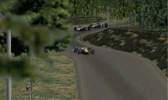
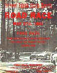
I have John Bradley at BAPOM
to thank for the spiffy program cover and track map. They really do fantastic
work and, based on the number of add-on tracks available, are quite prolific.
It's a wonder they can think of new cover art every time. I sometimes think
John's cover art is the best part of the track.
My GPL version of Pebble Beach is quite accurate as far as the track itself
goes. (The scenery is another matter.) I visited the modern roads several times,
sometimes in my car and sometimes on foot. I have elevations from my handheld
GPS and from USGS survey maps. The track is quite bumpy and I think I modeled
this pretty well. Yes, it's narrow but that just adds to the challenge, doesn't
it?.
 I took lots of digital photographs, some of which show up as textures in this
track. All of the roadside signs and much of the asphalt are actual photos. I
had no luck (nor talent) digitizing the actual trees that grow in the area, so I
borrowed (with permission) trees from other GPL tracks that closely approximate
the look and feel of the Pebble Beach area.
I took lots of digital photographs, some of which show up as textures in this
track. All of the roadside signs and much of the asphalt are actual photos. I
had no luck (nor talent) digitizing the actual trees that grow in the area, so I
borrowed (with permission) trees from other GPL tracks that closely approximate
the look and feel of the Pebble Beach area.
Acknowledgements
Many of the textures and 3DOs you see are borrowed from other, more talented,
track creators. With their kind permission I was able to decorate Pebble Beach
in something approaching its true colors. For their help, I am indebted to:
 Phil Flack/GPLEA (Snetterton), Ron Costin (Rolex), Smogbike (Rolex), John
Basara (Bremgarten), Van Gossum (Gossum), Andre Streu (Laguna Seca), Alain Bosco
(Road67), Martijn Keizer (Solitude), Dave Noonan (Imola), Ryk Penfold (Sopheve),
Mark Beckman (Kansas), Jonathan Slark (Kansas), Jim Erickson (Watkins Glen).
Phil Flack/GPLEA (Snetterton), Ron Costin (Rolex), Smogbike (Rolex), John
Basara (Bremgarten), Van Gossum (Gossum), Andre Streu (Laguna Seca), Alain Bosco
(Road67), Martijn Keizer (Solitude), Dave Noonan (Imola), Ryk Penfold (Sopheve),
Mark Beckman (Kansas), Jonathan Slark (Kansas), Jim Erickson (Watkins Glen).
Download
Want to take it for a spin?
Download the latest
version of Pebble Beach.